By Kristen N. Keegan and William F. Keegan for Connecticut Explored
At first, there were only the mental maps of the Native Americans, who easily traveled the whole region we now call Connecticut, along lightly marked trails, from memory. Connecticut’s first formal cartographers were Europeans working in the 17th century to record and capture the details they considered important, mainly to help lay claim to territory for their nations. The earliest locally produced maps exist only as manuscripts, their makers usually anonymous, ranging from rough sketches to visually sophisticated renderings of the landscape as seen by the mapmaker. Scattered across town, state, and private collections, they provide valuable glimpses of events great and small in Connecticut history.
During the 19th century, an astounding variety of maps were published for sale by a network of American surveyors, engravers, cartographers, and printers. These mapmakers were sometimes prolific and sometimes not; some became famous, and others remain obscure. Some maps of this period were produced wholly or partly in Connecticut, depicting places outside and inside the state. Although Connecticut’s role was relatively small, all of these cartographic efforts are part of the economic and social history of the state and the nation.
Manuscript Cartography and Its Uses
Manuscript maps, hand-drawn and unique, were most often made for specific reasons having to do with territories, boundaries, and properties. For example, in 1662, colonial officials asked Mohegan sachem Uncas to help them describe the extent of the territory of the Pequot tribe that had been conquered by an alliance of Englishmen, Mohegans, and Narragansetts in 1636. This map, probably drawn by a colonial official with input from Uncas, supported colonial claims to territory encompassing much of southeastern Connecticut, which had been divided among the victors decades before but was still being argued over with various parties.
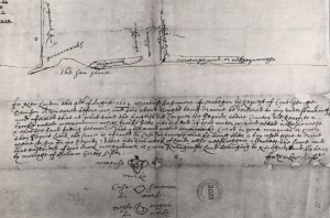
Plan of the Pequot Country and testimony of Uncas, Casasinomon, and Wesawegun, 1662 – University of Connecticut Libraries, Map and Geographic Information Center (MAGIC)
A little more than a century later, the colony was still arguing over Indian lands, this time directly with the Mohegans. The tribe commissioned a series of maps supporting their territorial claims, which they were making to a British royal commission. This “Mohegan Controversy” waxed and waned through most of the 18th century, with the first decision in favor of the Mohegans and the appeals (up through 1773) going in Connecticut’s favor.
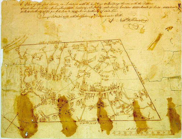
A little-known feature of colonial Connecticut mapping is the use of maps in certain religious disputes. Congregational churches were official branches of local government (known as ecclesiastical societies), and the location of a town’s meetinghouse (or church, as we know it) was a serious issue. The goal was to make access to the meetinghouse—which all the residents supported through “rates” (taxes) and were required on pain of fines to attend every Sunday—as equitable as possible. One result of such controversies was often a map of the society, depicting with painstaking attention the relative locations of the residents’ homes with respect to the proposed meetinghouse. How useful such maps were in any given case is difficult to say, but we appreciate them now for showing us where people lived at the time.
Military personnel sometimes created maps for planning related to fortifications and the defense of areas. Connecticut has seen relatively little direct military action, so maps of this kind are rare, with very little research done to establish how many might exist in the state. One fine example, however, is a detailed 1776 sketch John Trumbull made of the forts on the Thames River, establishing their locations and lines of fire. We can hope that in the future we will discover more maps of this kind.
Another use of mapping was—and is—to portray the results of land surveys, from state and town boundaries down to individual parcels of land. As late as the 1950s, groups of surveyors did their work with a compass or surveyor’s transit and a metal chain (usually 66 feet long), which was used much like a tape measure is today, despite its weight. Sometimes cadastral maps, showing some or all of the land parcels in a town, or even a single parcel, were drawn to clarify land ownership and boundaries. Like the meetinghouse maps, these can be fascinating historical artifacts, with details not otherwise available to the scholar. Manuscript maps of various kinds were made into at least the 19th century, as need arose. The information they provide to historians makes each one valuable—even when they are not also beautiful.
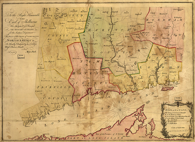
Colony of Connecticut in North-America by Moses Park, 1766 – University of Connecticut Libraries, Map and Geographic Information Center (MAGIC)
Printed Maps
In 1765 Moses Park of Preston (assisted by Asa Spaulding of Norwalk and Samuel Mott of Preston) surveyed and drafted the oldest printed map drawn in Connecticut by a Connecticut resident that portrayed the colony. Its engraver and printer are unknown, but according to Edmund Thompson’s Maps of Connecticut (reprinted by G. B. Manasek, 1995), its making was supported by the colony government, which gave Park authority to trespass on private land in order to survey the lines—an extraordinary action for the time. The earliest map both surveyed and printed in Connecticut is a 1771 chart of the Saybrook Bar, a large sandbar at the mouth of the Connecticut River. Captain Abner Parker of Saybrook compiled the chart and Abel Buell of New Haven engraved it. This is one of very few examples of navigational charts made in Connecticut; most were produced by or for national governments, either European or American, or by professional chart makers based in England or France.
Engraving is an often-overlooked part of the printing process, yet it was essential to the production of many images from the 15th century into the 20th, although serious competition from the lithography process emerged in the 1840s and from other new processes later on. Engravers were skilled artisans who created mirror images of existing drawings by making fine, shallow grooves on copper plates with needles, punches, and tools called gravers. They produced all kinds of illustrations for printed works, as well as plates for paper money.
Their time and expertise were expensive—as much as or more than an original survey that required a crew of men to cover the ground in person. For an example of the engraving costs, Thompson reported that the engraving of the Parker map of 1771 cost £30; the two large copper plates used for it cost £6.5. In 1798, as reported in Mary Sponberg Pedley’s The Commerce of Cartography (University of Chicago Press, 2005), the survey and compilation of a map of Maine and Massachusetts cost $1,136, while the engraving of its eight plates cost $1,100. Engraved plates were therefore sometimes re-used: Walter Ristow’s American Maps and Mapmakers (Wayne State University Press, 1985) notes that a plate of a Connecticut state map engraved and published around 1827 by Alfred Daggett of New Haven was re-used in 1831, 1836, 1847, and 1858, each time with new engravers’ and publishers’ names added. Although the less expensive technique of lithography (involving the chemical transfer of an image to a smooth piece of stone or paper for printing) was perfected by the 1840s, copper engraving remained in use for some time.
The printing of maps was not casually undertaken. According to Thompson, the engraving of Parker’s map was paid for through sales of legislatively authorized lottery tickets, which at the time was occasionally done to support public infrastructure projects. A more common approach was a subscription scheme under which customers committed to buy the work once it was produced. The 1813 map of Connecticut by Moses Warren and George Gillet (engraved by A. Reed of East Windsor and printed by Hudson & Goodwin of Hartford) was surveyed under direct authority granted by the state but was paid for by the surveyors themselves, with the backing of a subscription list. Of course, there was never a guarantee that all the subscribers would actually buy the map, so this was often a risky venture. Whether or not Warren, Gillet, and their publisher made back their investments, Gillet re-published the map—with updates—five times between 1820 and 1847 with the later versions engraved by Asaph Willard of Hartford. This longevity, its relative accuracy, and the investment of time and effort put into it by the mapmakers make this one of the more significant early Connecticut maps.
Who Were These Mapmakers?
Connecticut mapmakers came from a variety of backgrounds and professions. Moses Warren (1762-1835), one of the makers of the important 1813 state map, was a professional surveyor. Born in Hopkinton, Rhode Island, to Moses Warren Sr., he moved to Lyme, Connecticut, with his family in 1764. Among his many activities, he was a sergeant during the Revolutionary War, helped to survey the Western Reserve in 1796, surveyed the Connecticut/Massachusetts state line in 1826, and made an ecclesiastical map of the First Society of Lyme in 1815. He also speculated in turnpike development and served as a state legislator from Lyme and as county surveyor for New London County. George Gillet (1771-1853), his partner on the 1813 map, was a resident of Hebron who also worked as a professional surveyor and served as surveyor-general of Connecticut.
William Blodgett of Middletown (1754-1809) is a contrast to Warren and Gillet. He had produced a map of the state in 1791, which Joel Allen of Middletown engraved. His varied career, however, included stints as an officer in the Revolutionary War army, navy chaplain, storekeeper, artist, author, and musician, a variety that suggests either lack of success or lack of persistence. He only made two known notable maps, the 1791 one of Connecticut and another of Vermont.
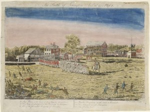
Etched by Amos Doolittle, The Battle of Lexington, April 19th. 1775, printer’s ink and watercolor on laid paper – Connecticut Historical Society and Connecticut History Online
Amos Doolittle of New Haven (1754-1832) was another such mapmaker. He was originally a silversmith by trade, for which he presumably learned engraving, a skill he turned to political purposes when in 1775 he published four unsophisticated printed engravings depicting the Battles of Lexington and Concord, clearly intended to inflame patriotic citizens to action. This launched his career in illustration, which included images in books ranging from almanacs to histories of Connecticut to various magazines and more (a published list of works to which he contributed runs to five and a half pages). His shop became an engraver’s and printer’s shop, which produced book plates, tickets, Yale diplomas, and other items. In addition, he produced maps for books and atlases—Bible atlases and editions of the Bible, national atlases, and geography textbooks. He did not survey most of these maps; they were adaptations of the works of others. Thus, although he “made” maps, he usually did not create them from original research. But he did also survey, engrave, and publish a map of his home city of New Haven, in 1812.
Doolittle’s geography textbook work is of particular interest because Jedidiah Morse (1761-1826) wrote some of those books when he was living in New Haven. A Yale graduate and Congregational minister born in Woodstock, Connecticut, Morse is known as the “father of American geography,” according to John Rennie Short’s Representing the Republic (Reaktion Books, 2004), a distinction he earned apparently by accident after he began publishing popular geography textbooks in 1784 (with Doolittle’s engraving work) to support himself financially. His was the first book of American geography written and published in the United States. Although Morse was not, strictly speaking, a mapmaker, his patriotic and exceptionalist vision of America and American geography influenced generations to think of his native New England as the source of authentic American culture.
The Heyday of Connecticut Mapmaking
Mapmaking activity in the Northeast increased substantially from the 1820s, buoyed by a flourishing economy and especially the thriving commerce in the region. Connecticut’s robust publishing industry, with its high concentration of engravers, printers, and publishers, made some notable contributions to this surge in activity. The best-known examples of these maps are those that were distributed among the upper echelon of society (usually for display) and therefore have survived.
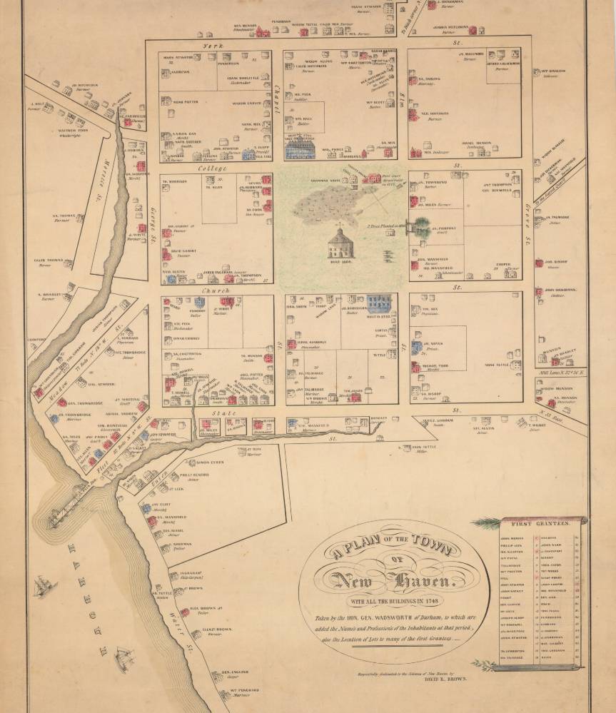
Plan of the Town of New Haven by James Wadsworth. New York: C. Currier, undated cadastral map – Connecticut Historical Society and Connecticut History Online
An unusual number of maps of ports was produced in 1824 and 1825, no doubt to capitalize on the market among the nouveau riche merchants and manufacturers of the region. Interestingly, several of these are stylistically very similar to a 1748 manuscript map of New Haven by General James Wadsworth of Durham, in which he depicted the homes of the so-called “better sort” as tiny sketches, complete with chimneys and windows. This particular map was copied and printed multiple times in the opening decades of the 19th century, a time when the new nation began trying to define itself. The style was copied for several ports. Middletown was surveyed and mapped by H. L. Barnum and engraved by J. T. Porter, both of that town. Stratford was mapped by James H. Linsley and Bridgeport by H. L. Barnum; Nathaniel and Simeon Smith Jocelyn of New Haven engraved both of these. An 1824 map of Hartford’s port by D. St. John and N. Goodwin (engraved by Asaph Willard), on the other hand, was in a much plainer and less detailed style.
Little is known about most of these individuals, but the Jocelyns are worthy of further note. Our survey of works in which they were involved indicates that, along with Doolittle, they were prolific producers of maps during the 1820s and 1830s, covering areas ranging from Connecticut to Greece to the Caribbean (the latter map includes “Piratical depredations and barbarities, from May 1818 to August 1825”). According to Ristow, the Jocelyns eventually relocated to New York, and while Nathaniel seems to have remained in the commercial engraving business, Simeon turned his energies to the anti-slavery movement around 1858.
The next major trend in mapping was the county map, usually a very large, wall-sized work for display, which became popular among well-off rural citizens during the 1850s. Bound county atlases containing maps of the individual towns began to appear in the latter part of the century. Most of both types were published in New York and Philadelphia, but Connecticut also published a small share.
One of the most surprising features of Connecticut’s mapmaking history, and that of the country in general, is the role of Newtown and the Newtown Academy. According to Ristow, John Homer French, who served as the school’s headmaster from 1852 to 1855, was also a civil engineer and surveyor who was active in New York State before and after his relatively short service in Newtown. When he was put in charge of an ongoing project to map the counties of New York in 1855, he recruited some of his former Newtown students: first Silas N. Beers, Frederick W. Beers, and D. Jackson Lake, and later Daniel G. Beers, Augustus Warner, J. Silliman Higgins, and others. These young men later established—outside of Connecticut—a series of publishing companies that ultimately portrayed all of the Northeast and much of the Old Northwest in county atlas form. Thus, the cartographic style and creative energy of much of the expanding nation was strongly, though not exclusively, influenced by Connecticut natives.
Many reasons for the production of manuscript maps remained as the 19th century ended, including the continuing dispute over Indian lands, but the disestablishment of the Congregational Church in 1818 meant that conflicts over meeting house locations were no longer a matter of public record. At the same time, improvements in printing and publishing machinery meant that printed maps (like books) were less expensive to produce and so became increasingly common. Earlier printed maps are notable for their scarcity, for their historical content, and often for their intentionally decorative appearance. Mapmakers continued their work, in Connecticut and elsewhere, in a context of greater abundance and of an increasingly broad audience. It was their predecessors, however, who first showed the way.
Kristen N. Keegan is an adjunct professor at Fairfield University and a PhD candidate in geography at the University of Connecticut. William F. Keegan is an independent scholar and a partner in Heritage Consultants LLC.
© Connecticut Explored. All rights reserved. This article originally appeared in Connecticut Explored (formerly Hog River Journal) Vol. 10/ No. 2, Spring 2012.
Note: ConnecticutHistory.org does not edit content originally published on another platform and therefore does not update any instances of outdated content or language.


