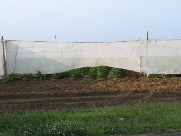
Shade grown tobacco, East Windsor
The Connecticut River forms the western border of this town, which is located in northeastern Hartford County. Incorporated from Windsor in 1768, East Windsor attracted settlers with its fertile soil for growing corn, oats, hay, and other crops. Its strategic location on the state’s main river also made it a key transfer station for goods moving between north and south. Small industry, such as textile and grist mills, grew up on its waterways, and by the 1900s shade tobacco became a dominant crop. Now, newer forms of commerce make up East Windsor’s economic base, but still-active drying sheds and farms speak to agriculture’s ongoing importance in the town.
Featured
Favoring local cherry and pine woods, this furniture maker introduced Philadelphia-style flair to New England consumers. …[more]
Learn More
58529
MIBU6QGE
1
apsa
50
default
2589
https://connecticuthistory.org/wp-content/plugins/zotpress/
%7B%22status%22%3A%22success%22%2C%22updateneeded%22%3Afalse%2C%22instance%22%3Afalse%2C%22meta%22%3A%7B%22request_last%22%3A0%2C%22request_next%22%3A0%2C%22used_cache%22%3Atrue%7D%2C%22data%22%3A%5B%7B%22key%22%3A%22C89MFUDR%22%2C%22library%22%3A%7B%22id%22%3A58529%7D%2C%22meta%22%3A%7B%22lastModifiedByUser%22%3A%7B%22id%22%3A14399323%2C%22username%22%3A%22kquotap%22%2C%22name%22%3A%22%22%2C%22links%22%3A%7B%22alternate%22%3A%7B%22href%22%3A%22https%3A%5C%2F%5C%2Fwww.zotero.org%5C%2Fkquotap%22%2C%22type%22%3A%22text%5C%2Fhtml%22%7D%7D%7D%2C%22numChildren%22%3A0%7D%2C%22bib%22%3A%22%3Cdiv%20class%3D%5C%22csl-bib-body%5C%22%20style%3D%5C%22line-height%3A%201.35%3B%20padding-left%3A%201em%3B%20text-indent%3A-1em%3B%5C%22%3E%5Cn%20%20%3Cdiv%20class%3D%5C%22csl-entry%5C%22%3E%26%23x201C%3BEast%20Windsor%20Collection.%26%23x201D%3B%20%3Ca%20class%3D%27zp-ItemURL%27%20href%3D%27https%3A%5C%2F%5C%2Fctdigitalarchive.org%5C%2Fislandora%5C%2Fsearch%5C%2Fmods_titleInfo_title_mt%25253A%252528East%25255C%2520Windsor%252529%2520OR%2520mods_subject_geographic_mt%25253A%252528East%25255C%2520Windsor%252529%27%3Ehttps%3A%5C%2F%5C%2Fctdigitalarchive.org%5C%2Fislandora%5C%2Fsearch%5C%2Fmods_titleInfo_title_mt%25253A%252528East%25255C%2520Windsor%252529%2520OR%2520mods_subject_geographic_mt%25253A%252528East%25255C%2520Windsor%252529%3C%5C%2Fa%3E.%3C%5C%2Fdiv%3E%5Cn%3C%5C%2Fdiv%3E%22%2C%22data%22%3A%7B%22itemType%22%3A%22document%22%2C%22title%22%3A%22East%20Windsor%20Collection%22%2C%22creators%22%3A%5B%5D%2C%22abstractNote%22%3A%22%22%2C%22date%22%3A%22%22%2C%22language%22%3A%22%22%2C%22url%22%3A%22https%3A%5C%2F%5C%2Fctdigitalarchive.org%5C%2Fislandora%5C%2Fsearch%5C%2Fmods_titleInfo_title_mt%25253A%252528East%25255C%2520Windsor%252529%2520OR%2520mods_subject_geographic_mt%25253A%252528East%25255C%2520Windsor%252529%22%2C%22collections%22%3A%5B%22MIBU6QGE%22%2C%229TVU3F5R%22%5D%2C%22dateModified%22%3A%222020-08-28T03%3A04%3A55Z%22%7D%7D%2C%7B%22key%22%3A%22NCIQ5AGN%22%2C%22library%22%3A%7B%22id%22%3A58529%7D%2C%22meta%22%3A%7B%22lastModifiedByUser%22%3A%7B%22id%22%3A14399323%2C%22username%22%3A%22kquotap%22%2C%22name%22%3A%22%22%2C%22links%22%3A%7B%22alternate%22%3A%7B%22href%22%3A%22https%3A%5C%2F%5C%2Fwww.zotero.org%5C%2Fkquotap%22%2C%22type%22%3A%22text%5C%2Fhtml%22%7D%7D%7D%2C%22parsedDate%22%3A%221850%22%2C%22numChildren%22%3A1%7D%2C%22bib%22%3A%22%3Cdiv%20class%3D%5C%22csl-bib-body%5C%22%20style%3D%5C%22line-height%3A%201.35%3B%20padding-left%3A%201em%3B%20text-indent%3A-1em%3B%5C%22%3E%5Cn%20%20%3Cdiv%20class%3D%5C%22csl-entry%5C%22%3E%26%23x201C%3BMap%20-%20East%20Windsor%2C%20Hartford%20County%2C%20Conn.%20%28Petersen%20Collection%29.%26%23x201D%3B%201850.%20%3Ca%20class%3D%27zp-ItemURL%27%20href%3D%27https%3A%5C%2F%5C%2Fflic.kr%5C%2Fp%5C%2F6bk8qr%27%3Ehttps%3A%5C%2F%5C%2Fflic.kr%5C%2Fp%5C%2F6bk8qr%3C%5C%2Fa%3E%20%28November%2017%2C%202016%29.%3C%5C%2Fdiv%3E%5Cn%3C%5C%2Fdiv%3E%22%2C%22data%22%3A%7B%22itemType%22%3A%22map%22%2C%22title%22%3A%22Map%20-%20East%20Windsor%2C%20Hartford%20County%2C%20Conn.%20%28Petersen%20Collection%29%22%2C%22creators%22%3A%5B%5D%2C%22abstractNote%22%3A%22%22%2C%22mapType%22%3A%22%22%2C%22scale%22%3A%22%22%2C%22date%22%3A%22ca.%201850%22%2C%22language%22%3A%22%22%2C%22ISBN%22%3A%22%22%2C%22url%22%3A%22https%3A%5C%2F%5C%2Fflic.kr%5C%2Fp%5C%2F6bk8qr%22%2C%22collections%22%3A%5B%22MIBU6QGE%22%2C%229TVU3F5R%22%5D%2C%22dateModified%22%3A%222016-11-17T17%3A53%3A43Z%22%7D%7D%2C%7B%22key%22%3A%22K8BIASWD%22%2C%22library%22%3A%7B%22id%22%3A58529%7D%2C%22meta%22%3A%7B%22lastModifiedByUser%22%3A%7B%22id%22%3A14399323%2C%22username%22%3A%22kquotap%22%2C%22name%22%3A%22%22%2C%22links%22%3A%7B%22alternate%22%3A%7B%22href%22%3A%22https%3A%5C%2F%5C%2Fwww.zotero.org%5C%2Fkquotap%22%2C%22type%22%3A%22text%5C%2Fhtml%22%7D%7D%7D%2C%22parsedDate%22%3A%222016%22%2C%22numChildren%22%3A0%7D%2C%22bib%22%3A%22%3Cdiv%20class%3D%5C%22csl-bib-body%5C%22%20style%3D%5C%22line-height%3A%201.35%3B%20padding-left%3A%201em%3B%20text-indent%3A-1em%3B%5C%22%3E%5Cn%20%20%3Cdiv%20class%3D%5C%22csl-entry%5C%22%3E%26%23x201C%3BConnecticut%20Trolley%20Museum.%26%23x201D%3B%202016.%20%3Ca%20class%3D%27zp-ItemURL%27%20href%3D%27http%3A%5C%2F%5C%2Fwww.ct-trolley.org%5C%2F%27%3Ehttp%3A%5C%2F%5C%2Fwww.ct-trolley.org%5C%2F%3C%5C%2Fa%3E.%3C%5C%2Fdiv%3E%5Cn%3C%5C%2Fdiv%3E%22%2C%22data%22%3A%7B%22itemType%22%3A%22webpage%22%2C%22title%22%3A%22Connecticut%20Trolley%20Museum%22%2C%22creators%22%3A%5B%5D%2C%22abstractNote%22%3A%22%22%2C%22date%22%3A%222016%22%2C%22url%22%3A%22http%3A%5C%2F%5C%2Fwww.ct-trolley.org%5C%2F%22%2C%22language%22%3A%22%22%2C%22collections%22%3A%5B%228V92VC4J%22%2C%222JJ95PWR%22%2C%22MIBU6QGE%22%2C%22BEUKH3W9%22%2C%225882U9Z3%22%2C%22SJBAW48M%22%5D%2C%22dateModified%22%3A%222016-11-17T17%3A49%3A42Z%22%7D%7D%2C%7B%22key%22%3A%22W64AMS8V%22%2C%22library%22%3A%7B%22id%22%3A58529%7D%2C%22meta%22%3A%7B%22lastModifiedByUser%22%3A%7B%22id%22%3A14399323%2C%22username%22%3A%22kquotap%22%2C%22name%22%3A%22%22%2C%22links%22%3A%7B%22alternate%22%3A%7B%22href%22%3A%22https%3A%5C%2F%5C%2Fwww.zotero.org%5C%2Fkquotap%22%2C%22type%22%3A%22text%5C%2Fhtml%22%7D%7D%7D%2C%22parsedDate%22%3A%222016%22%2C%22numChildren%22%3A1%7D%2C%22bib%22%3A%22%3Cdiv%20class%3D%5C%22csl-bib-body%5C%22%20style%3D%5C%22line-height%3A%201.35%3B%20padding-left%3A%201em%3B%20text-indent%3A-1em%3B%5C%22%3E%5Cn%20%20%3Cdiv%20class%3D%5C%22csl-entry%5C%22%3E%26%23x201C%3BEast%20Windsor%20-%20WPA%20Architectural%20Survey.%26%23x201D%3B%202016.%20%3Ci%3EConnecticut%20State%20Library%20Digital%20Collections%3C%5C%2Fi%3E.%20%3Ca%20class%3D%27zp-ItemURL%27%20href%3D%27http%3A%5C%2F%5C%2Fcslib.cdmhost.com%5C%2Fcdm%5C%2Fsearch%5C%2Fcollection%5C%2Fp4005coll7%5C%2Fsearchterm%5C%2FEast%2520Windsor%5C%2Ffield%5C%2Ftowns%5C%2Fmode%5C%2Fexact%5C%2Fconn%5C%2Fand%5C%2Forder%5C%2Ftitle%27%3Ehttp%3A%5C%2F%5C%2Fcslib.cdmhost.com%5C%2Fcdm%5C%2Fsearch%5C%2Fcollection%5C%2Fp4005coll7%5C%2Fsearchterm%5C%2FEast%2520Windsor%5C%2Ffield%5C%2Ftowns%5C%2Fmode%5C%2Fexact%5C%2Fconn%5C%2Fand%5C%2Forder%5C%2Ftitle%3C%5C%2Fa%3E%20%28January%205%2C%202015%29.%3C%5C%2Fdiv%3E%5Cn%3C%5C%2Fdiv%3E%22%2C%22data%22%3A%7B%22itemType%22%3A%22webpage%22%2C%22title%22%3A%22East%20Windsor%20-%20WPA%20Architectural%20Survey%22%2C%22creators%22%3A%5B%5D%2C%22abstractNote%22%3A%22%22%2C%22date%22%3A%222016%22%2C%22url%22%3A%22http%3A%5C%2F%5C%2Fcslib.cdmhost.com%5C%2Fcdm%5C%2Fsearch%5C%2Fcollection%5C%2Fp4005coll7%5C%2Fsearchterm%5C%2FEast%2520Windsor%5C%2Ffield%5C%2Ftowns%5C%2Fmode%5C%2Fexact%5C%2Fconn%5C%2Fand%5C%2Forder%5C%2Ftitle%22%2C%22language%22%3A%22%22%2C%22collections%22%3A%5B%22MIBU6QGE%22%2C%229TVU3F5R%22%5D%2C%22dateModified%22%3A%222016-11-17T17%3A49%3A16Z%22%7D%7D%2C%7B%22key%22%3A%22ETKPSX9M%22%2C%22library%22%3A%7B%22id%22%3A58529%7D%2C%22meta%22%3A%7B%22lastModifiedByUser%22%3A%7B%22id%22%3A14399323%2C%22username%22%3A%22kquotap%22%2C%22name%22%3A%22%22%2C%22links%22%3A%7B%22alternate%22%3A%7B%22href%22%3A%22https%3A%5C%2F%5C%2Fwww.zotero.org%5C%2Fkquotap%22%2C%22type%22%3A%22text%5C%2Fhtml%22%7D%7D%7D%2C%22creatorSummary%22%3A%22Stiles%22%2C%22parsedDate%22%3A%221891%22%2C%22numChildren%22%3A0%7D%2C%22bib%22%3A%22%3Cdiv%20class%3D%5C%22csl-bib-body%5C%22%20style%3D%5C%22line-height%3A%201.35%3B%20padding-left%3A%201em%3B%20text-indent%3A-1em%3B%5C%22%3E%5Cn%20%20%3Cdiv%20class%3D%5C%22csl-entry%5C%22%3EStiles%2C%20Henry.%201891.%201%20%3Ci%3EThe%20History%20and%20Genealogies%20of%20Ancient%20Windsor%2C%20Connecticut%20Including%20East%20Windsor%2C%20South%20Windsor%2C%20Bloomfield%2C%20Windsor%20Locks%2C%20and%20Ellington.%201635-1891.%20History%3C%5C%2Fi%3E.%20Hartford%2C%20CT%3A%20Case%2C%20Lockwood%20%26amp%3B%20Brainard%20Company.%20%3Ca%20class%3D%27zp-ItemURL%27%20href%3D%27http%3A%5C%2F%5C%2Fwww.archive.org%5C%2Fstream%5C%2Fhistorygenealogi01stil%23page%5C%2Fn7%5C%2Fmode%5C%2F2up%27%3Ehttp%3A%5C%2F%5C%2Fwww.archive.org%5C%2Fstream%5C%2Fhistorygenealogi01stil%23page%5C%2Fn7%5C%2Fmode%5C%2F2up%3C%5C%2Fa%3E.%3C%5C%2Fdiv%3E%5Cn%3C%5C%2Fdiv%3E%22%2C%22data%22%3A%7B%22itemType%22%3A%22book%22%2C%22title%22%3A%22The%20History%20and%20Genealogies%20of%20Ancient%20Windsor%2C%20Connecticut%20Including%20East%20Windsor%2C%20South%20Windsor%2C%20Bloomfield%2C%20Windsor%20Locks%2C%20and%20Ellington.%201635-1891.%20History%22%2C%22creators%22%3A%5B%7B%22creatorType%22%3A%22author%22%2C%22firstName%22%3A%22Henry%22%2C%22lastName%22%3A%22Stiles%22%7D%5D%2C%22abstractNote%22%3A%22%22%2C%22date%22%3A%221891%22%2C%22language%22%3A%22%22%2C%22ISBN%22%3A%22%22%2C%22url%22%3A%22http%3A%5C%2F%5C%2Fwww.archive.org%5C%2Fstream%5C%2Fhistorygenealogi01stil%23page%5C%2Fn7%5C%2Fmode%5C%2F2up%22%2C%22collections%22%3A%5B%22CBS8VU4X%22%2C%22MIBU6QGE%22%2C%22CPAASSCT%22%2C%228A2AUT5D%22%2C%225K9ZVKVH%22%2C%226RXV2KTE%22%2C%22GZTD52EF%22%2C%22MKX7MGG7%22%2C%22R2AQWUJG%22%2C%22VT62V6RT%22%2C%22ZMKCNPR2%22%2C%226E7BR5T2%22%5D%2C%22dateModified%22%3A%222013-02-09T15%3A40%3A41Z%22%7D%7D%2C%7B%22key%22%3A%228VP5Q7HC%22%2C%22library%22%3A%7B%22id%22%3A58529%7D%2C%22meta%22%3A%7B%22lastModifiedByUser%22%3A%7B%22id%22%3A14399323%2C%22username%22%3A%22kquotap%22%2C%22name%22%3A%22%22%2C%22links%22%3A%7B%22alternate%22%3A%7B%22href%22%3A%22https%3A%5C%2F%5C%2Fwww.zotero.org%5C%2Fkquotap%22%2C%22type%22%3A%22text%5C%2Fhtml%22%7D%7D%7D%2C%22creatorSummary%22%3A%22Stiles%22%2C%22parsedDate%22%3A%221891%22%2C%22numChildren%22%3A0%7D%2C%22bib%22%3A%22%3Cdiv%20class%3D%5C%22csl-bib-body%5C%22%20style%3D%5C%22line-height%3A%201.35%3B%20padding-left%3A%201em%3B%20text-indent%3A-1em%3B%5C%22%3E%5Cn%20%20%3Cdiv%20class%3D%5C%22csl-entry%5C%22%3EStiles%2C%20Henry.%201891.%202%20%3Ci%3EThe%20History%20and%20Genealogies%20of%20Ancient%20Windsor%2C%20Connecticut%20Including%20East%20Windsor%2C%20South%20Windsor%2C%20Bloomfield%2C%20Windsor%20Locks%2C%20and%20Ellington.%201635-1891.%20Genealogies%20and%20Biographies%3C%5C%2Fi%3E.%20Hartford%2C%20CT%3A%20Case%2C%20Lockwood%20%26amp%3B%20Brainard%20Company.%20%3Ca%20class%3D%27zp-ItemURL%27%20href%3D%27http%3A%5C%2F%5C%2Fwww.archive.org%5C%2Fstream%5C%2Fhistorygenealogi02stil%23page%5C%2Fn5%5C%2Fmode%5C%2F2up%27%3Ehttp%3A%5C%2F%5C%2Fwww.archive.org%5C%2Fstream%5C%2Fhistorygenealogi02stil%23page%5C%2Fn5%5C%2Fmode%5C%2F2up%3C%5C%2Fa%3E.%3C%5C%2Fdiv%3E%5Cn%3C%5C%2Fdiv%3E%22%2C%22data%22%3A%7B%22itemType%22%3A%22book%22%2C%22title%22%3A%22The%20History%20and%20Genealogies%20of%20Ancient%20Windsor%2C%20Connecticut%20Including%20East%20Windsor%2C%20South%20Windsor%2C%20Bloomfield%2C%20Windsor%20Locks%2C%20and%20Ellington.%201635-1891.%20Genealogies%20and%20Biographies%22%2C%22creators%22%3A%5B%7B%22creatorType%22%3A%22author%22%2C%22firstName%22%3A%22Henry%22%2C%22lastName%22%3A%22Stiles%22%7D%5D%2C%22abstractNote%22%3A%22%22%2C%22date%22%3A%221891%22%2C%22language%22%3A%22%22%2C%22ISBN%22%3A%22%22%2C%22url%22%3A%22http%3A%5C%2F%5C%2Fwww.archive.org%5C%2Fstream%5C%2Fhistorygenealogi02stil%23page%5C%2Fn5%5C%2Fmode%5C%2F2up%22%2C%22collections%22%3A%5B%22CBS8VU4X%22%2C%22MIBU6QGE%22%2C%22CPAASSCT%22%2C%228A2AUT5D%22%2C%225K9ZVKVH%22%2C%226RXV2KTE%22%2C%22GZTD52EF%22%2C%22MKX7MGG7%22%2C%22R2AQWUJG%22%2C%22VT62V6RT%22%2C%22ZMKCNPR2%22%2C%226E7BR5T2%22%5D%2C%22dateModified%22%3A%222013-02-09T15%3A40%3A34Z%22%7D%7D%2C%7B%22key%22%3A%22PSEVC8PD%22%2C%22library%22%3A%7B%22id%22%3A58529%7D%2C%22meta%22%3A%7B%22lastModifiedByUser%22%3A%7B%22id%22%3A14399323%2C%22username%22%3A%22kquotap%22%2C%22name%22%3A%22%22%2C%22links%22%3A%7B%22alternate%22%3A%7B%22href%22%3A%22https%3A%5C%2F%5C%2Fwww.zotero.org%5C%2Fkquotap%22%2C%22type%22%3A%22text%5C%2Fhtml%22%7D%7D%7D%2C%22creatorSummary%22%3A%22O.H.%20Bailey%20%26%20Company%22%2C%22parsedDate%22%3A%221876%22%2C%22numChildren%22%3A0%7D%2C%22bib%22%3A%22%3Cdiv%20class%3D%5C%22csl-bib-body%5C%22%20style%3D%5C%22line-height%3A%201.35%3B%20padding-left%3A%201em%3B%20text-indent%3A-1em%3B%5C%22%3E%5Cn%20%20%3Cdiv%20class%3D%5C%22csl-entry%5C%22%3EO.H.%20Bailey%20%26amp%3B%20Company.%201876.%20%26%23x201C%3BBroad%20Brook%2C%20Conn.%26%23x201D%3B%20%3Ca%20class%3D%27zp-ItemURL%27%20href%3D%27http%3A%5C%2F%5C%2Fwww.cthistoryonline.org%5C%2Fcdm%5C%2Fref%5C%2Fcollection%5C%2Fcho%5C%2Fid%5C%2F15033%27%3Ehttp%3A%5C%2F%5C%2Fwww.cthistoryonline.org%5C%2Fcdm%5C%2Fref%5C%2Fcollection%5C%2Fcho%5C%2Fid%5C%2F15033%3C%5C%2Fa%3E%20%28March%207%2C%202012%29.%3C%5C%2Fdiv%3E%5Cn%3C%5C%2Fdiv%3E%22%2C%22data%22%3A%7B%22itemType%22%3A%22map%22%2C%22title%22%3A%22Broad%20Brook%2C%20Conn%22%2C%22creators%22%3A%5B%7B%22creatorType%22%3A%22cartographer%22%2C%22firstName%22%3A%22%22%2C%22lastName%22%3A%22O.H.%20Bailey%20%26%20Company%22%7D%5D%2C%22abstractNote%22%3A%22%22%2C%22mapType%22%3A%22Bird%27s-eye%22%2C%22scale%22%3A%22%22%2C%22date%22%3A%22ca.%201876%22%2C%22language%22%3A%22%22%2C%22ISBN%22%3A%22%22%2C%22url%22%3A%22http%3A%5C%2F%5C%2Fwww.cthistoryonline.org%5C%2Fcdm%5C%2Fref%5C%2Fcollection%5C%2Fcho%5C%2Fid%5C%2F15033%22%2C%22collections%22%3A%5B%22MIBU6QGE%22%2C%229TVU3F5R%22%5D%2C%22dateModified%22%3A%222012-11-13T14%3A28%3A25Z%22%7D%7D%5D%7D
“Map - East Windsor, Hartford County, Conn. (Petersen Collection).” 1850.
https://flic.kr/p/6bk8qr (November 17, 2016).
“Connecticut Trolley Museum.” 2016.
http://www.ct-trolley.org/.
Stiles, Henry. 1891. 1
The History and Genealogies of Ancient Windsor, Connecticut Including East Windsor, South Windsor, Bloomfield, Windsor Locks, and Ellington. 1635-1891. History. Hartford, CT: Case, Lockwood & Brainard Company.
http://www.archive.org/stream/historygenealogi01stil#page/n7/mode/2up.
Stiles, Henry. 1891. 2
The History and Genealogies of Ancient Windsor, Connecticut Including East Windsor, South Windsor, Bloomfield, Windsor Locks, and Ellington. 1635-1891. Genealogies and Biographies. Hartford, CT: Case, Lockwood & Brainard Company.
http://www.archive.org/stream/historygenealogi02stil#page/n5/mode/2up.
O.H. Bailey & Company. 1876. “Broad Brook, Conn.”
http://www.cthistoryonline.org/cdm/ref/collection/cho/id/15033 (March 7, 2012).


