


By Kate Steinway
In the late 1800s, panoramic illustrations, known as bird’s-eye views, became a popular means of portraying towns throughout Connecticut as the industrial age transformed them from agrarian hamlets into booming economic centers. Bird’s-eye view lithographs, such as the one seen here, earned their name because the city or town depicted was rendered as though seen from a high vantage point. Although these prints often idealized the built environment’s virtues and downplayed its flaws, they nonetheless provide historians with useful information.

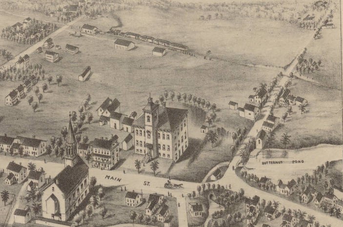
Broad Brook, Conn. Boston, MA: O.H. Bailey, ca. 1876 – Connecticut Historical Society and Connecticut Historical Society
This view of Broad Brook, a village of East Windsor, depicts a classic New England mill town. The Broad Brook Manufacturing Company, a woolen mill, dominates the foreground. Its multistory masonry buildings are unusual because they were constructed of stone rather than brick, a more typical material for 19th-century factory architecture.
The mill owners constructed two dams to power the factory’s machinery: one by the bridge on Main Street and another by the large smokestack in the foreground. Butternut Pond (to the right) served as an additional source of water power. After the introduction of steam, the dams continued to be useful sources of power.
The owners of the Broad Brook Manufacturing Company adopted the paternalistic attitude of many early factory proprietors and provided houses for their employees to rent. Most of this housing is visible along Main Street (left of the factory)—and much of it is still there today.
The prosperity of all mill towns depended upon accessible transportation, generally the railroad, which carried their goods to market throughout the state and beyond. The Connecticut Central Railroad opened from East Hartford to Springfield, Massachusetts, in January, 1876. In this view, a northbound train is visible in the upper right, approaching the Broad Brook station.
Kate Steinway, the former Executive Director of the Connecticut Historical Society (CHS) in Hartford, curated the traveling exhibition, Hamlets & Hubs; Bird’s-Eye Views of Connecticut Towns, 1849-1908 (1987-88), from which this article is derived, while Curator of Prints and Photographs at CHS.


