


By Nancy Finlay
In 1650, representatives from New Netherlands and New England met in Hartford to try to settle their boundary disputes. The Dutch trading post called the Huys de Hope—the House of Hope—located on the Connecticut River at the mouth of the Little River had been established in 1633; Thomas Hooker and his party had arrived three years later, establishing Hartford just upstream from the Dutch post. English settlers kept pouring in during the 1630s and 1640s, establishing new towns up and down the river and along the coast. On October 12, the colonial representatives signed a treaty, provisionally relinquishing Dutch claims to the Connecticut River Valley. Conflicts between the Dutch and English continued for another 20 years, until 1674, when the Dutch finally ceded New Netherlands to the English.

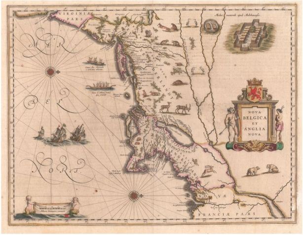
New Amsterdam, or New York. Map from The New and Unknown World, by Arnoldus Montanus, Amsterdam, 1671 – Connecticut Historical Society, 2011.501.0
The earliest Dutch maps showed Connecticut as a wilderness inhabited by wild beasts and “Indians” (diverse indigenous groups about which Europeans knew relatively little). A map of New Netherlands and New England from Willem Blaeu’s atlas, published in Amsterdam in 1635, is oriented with west at the top, making it hard to read. No settlements at all appear along the Versche (or Fresh) River, the Dutch name for the Connecticut River. A map from De Nieuwe en Onbekende Weereld (The New and Unknown World), a 1671 account of America by the Dutch scholar Arnoldus Montanus, looks much more familiar and includes both Dutch and English names. Hartford appears as “Herford” and the House of Hope as the “Fort de Goede Hoop.” Other Dutch and English names are commingled along the Connecticut River and Long Island Sound. Johannes van Keulen’s chart of Long Island Sound and the Connecticut and Hudson Rivers was published in 1687, more than 10 years after New Netherlands was ceded to England by the Dutch, but it is based on surveys from the 1660s and shows many Dutch place names side by side with the names of English towns and geographical features. Originally meant as a practical aid to navigation, it’s a reminder that even at the end of the 17th century European-style roads remained rough or non-existent and most European arrivals to the area traveled by sea.
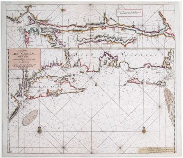
Chart of the Coast of New York and New England. Published by Johannes van Keulen, Amsterdam, 1687 – Connecticut Historical Society, 2012.172.2
The Dutch names that persist on Dutch maps through the end of the 17th century and beyond recall the golden age of Dutch exploration and territorial expansion, a time when Connecticut was part of New Netherlands. The memory of these early explorers is preserved in some Hartford place names, such as Dutch Point, Huyshope Avenue, and Adriaen’s Landing. Dutch Point is the site of the original Dutch settlement; Huyshope Avenue takes its name from the House of Hope, and Adriaen’s Landing commemorates Adriaen Block, the Dutch navigator who was the first European to explore the Connecticut River.
Nancy Finlay, formerly Curator of Graphics at the Connecticut Historical Society, is the editor of Picturing Victorian America: Prints by the Kellogg Brothers of Hartford, Connecticut, 1830-1880.
© Connecticut Public Broadcasting Network and Connecticut Historical Society. All rights reserved. This article originally appeared on Connecticut History | WNPR News
Note: ConnecticutHistory.org does not edit content originally published on another platform and therefore does not update any instances of outdated content or language.


