


By Walter W. Woodward for Connecticut Explored
Originally published January 25, 2013
The key document mapping out Connecticut’s original boundaries wasn’t in fact a map. It was, instead, a royal charter. The Charter of 1662—arguably the most important document in Connecticut’s history—contains among its other provisions a written description of the colony’s boundaries that served the same function as a drawn map. The text reads:
We, of Our abundant Grace, . . . have given, granted, and confirmed. . . unto the said Governor and Company. . . all that Part of Our Dominions in New-England . . . bounded on the East by . . . Narraganset-Bay, . . . on the North by the Line of the Massachusetts-Plantation; and on the South by the Sea; and in Longitude . . . From the said Narraganset-Bay on the East, to the South Sea on the West Part . . .
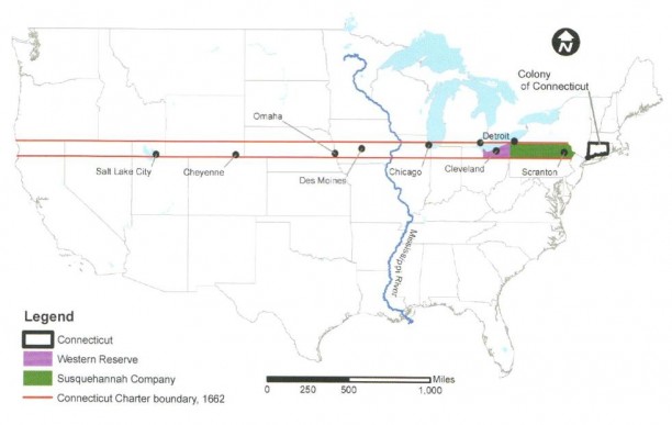
Charter of 1662 Sets Out Expansive Vision of Connecticut
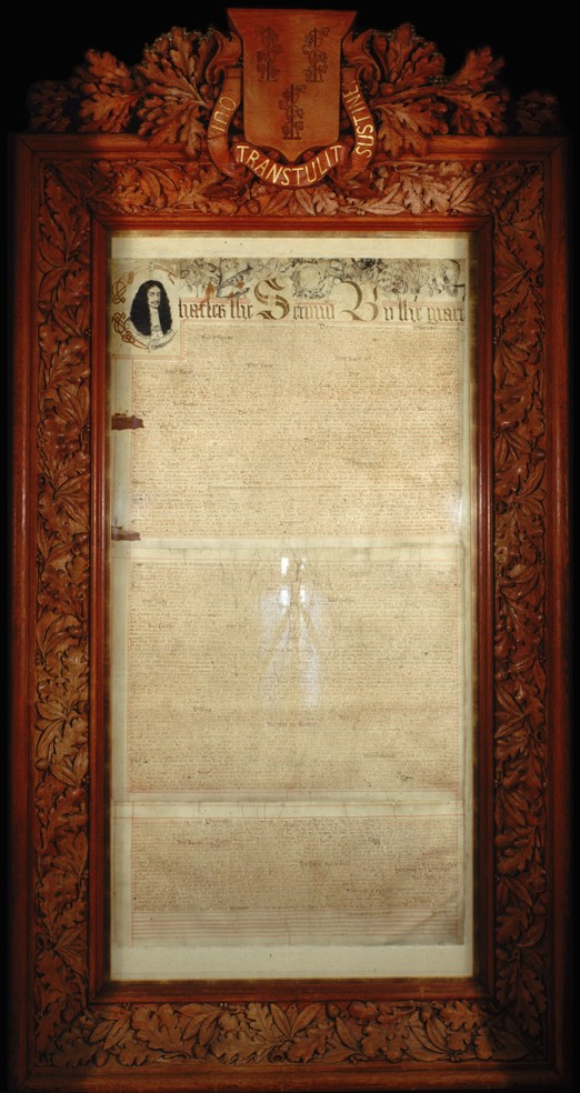
Charter of the Colony of Connecticut, 1662 – Connecticut State Library
The “South Sea”—what we call the Pacific Ocean—was well known to early navigators, but its exact location in relation to Connecticut Colony was unclear in 1662. What England’s King Charles II effectively granted Connecticut through that grandiose wording was a swath of land some 70 miles north to south, stretching from the Narragansett Bay on the east to the northern California/Oregon coast just west of Mount Shasta. Had the charter’s provisions held through the centuries, our state today would include the cities of Scranton, Erie, Cleveland, Detroit, Chicago, Des Moines, Omaha, Cheyenne, and Salt Lake City.
Historians have long marveled at the generous provisions of the 1662 royal charter. In addition to the transcontinental footprint, the king also granted Connecticut virtually complete governmental autonomy more than a century before the Declaration of Independence. The charter’s provisions in this regard were so complete that when other states scrambled to create new constitutions at the start of the American Revolution, Connecticut simply replaced the king’s name with “the people of Connecticut” and continued using the charter as its constitution until 1818!
John Winthrop Jr. Helps Secure Generous Charter
Charles II’s charter generosity is even more surprising given that he had every reason to be furious with his New England subjects. Connecticut was a Puritan colony, and the Puritans had been instrumental in the execution of his father, Charles I. Furthermore, during the period the charter was issued, several of the men who had signed the king’s death warrant were being sheltered from prosecution in Connecticut and other parts of New England.
The king’s benevolence was in large part a response to the persuasive powers of the Connecticut Colony’s Governor John Winthrop Jr., who in addition to serving as Connecticut’s governor for 19 years was also America’s leading scientist, used his London scientific connections to access the king’s patronage network and ultimately the monarch himself. Charles II appears to have warmed to Winthrop—with whom he shared a surprising physical resemblance—seeing him as an ideal ally to help institute a royal plan to combine all the colonies of New England into a single entity under crown rule. Connecticut’s especially favorable charter provisions were part of his effort to win Winthrop over to this plan.
King’s Plan to Consolidate Colonies Fails
But when Winthrop—having gotten the charter—refused to play along with Charles’s consolidation scheme, the king quickly issued new competing charters that reduced Connecticut’s transcontinental holdings to a small area of land east of the Connecticut River. Connecticut’s officials, however, steadfastly maintained that the 1662 Charter was the only valid Connecticut charter. This hotly contested position helped them retain Connecticut’s original lands as far west as the New York border, absorb the New Haven Colony (finalized in 1665), and later lay claim in the future to large areas of Ohio (the Connecticut Western Reserve and the Firelands) during the early days of the new United States. Connecticut’s imprint is still an important presence in those parts of the Midwest, a direct result of the 1662 map that wasn’t a map at all.
Walter W. Woodward is the Connecticut State Historian.
© Connecticut Explored. All rights reserved. This article originally appeared in Connecticut Explored (formerly Hog River Journal ) Vol. 10/ No. 2, Spring 2012.
Note: ConnecticutHistory.org does not edit content originally published on another platform and therefore does not update any instances of outdated content or language.


