
Other CT Humanities Programs

Creative Commons Licensing

FUNDING CUTS IMPACT CT HUMANITIES: Help CT Humanities navigate recent funding cuts and continue our vital work across Connecticut. All donations made to CTH will be matched dollar-for-dollar up to $50,000. Donate today!
Now Viewing:
John Winthrop Jr.
From the State Historian: The Map That Wasn’t a Map
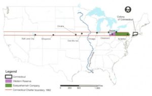
The Charter of 1662 described Connecticut boundaries that extended all the way to the the Pacific Ocean!
Read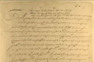
The Charter of 1662
The Connecticut Charter, which provided the basis for Connecticut government until 1818, was secured because of Connecticut’s realization after the restoration of Charles II to the English throne in 1660 that the government of the colony lacked any legal foundation.
Read
Elizabeth Fones Winthrop Feake Hallett Helps Found Greenwich
In the middle of the 17th century, Elizabeth Fones Winthrop Feake Hallett played an integral part in purchasing the land that became Greenwich, Connecticut.
Read
An Old Saybrook Borough has a Stately History
The Borough of Fenwick, a well-known summer community in Old Saybrook, is named for George Fenwick and his family.
Read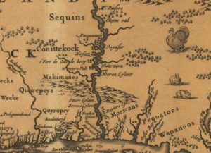
Timeline: Settlement of the Colony of Connecticut
A timeline displaying the major events leading to Connecticut statehood, including its settlement by the Dutch, the origins of Hartford, Wethersfield, and Windsor, the founding of the Connecticut, New Haven, and Saybrook colonies, and Connecticut’s acquisition of a formal charter from England.
Read
Lion Gardiner Helps to Fortify Early Old Saybrook
In 1635, the governor of the Saybrook colony hired engineer and soldier Lion Gardiner to build a critically needed fort for protection from both the Dutch colonists and local Native American tribes.
ReadMore Articles